
Austrian glaciers disintegrating due to climate change, say scientists
Austrian glaciers are rapidly shrinking due to climate change, which threatens the region's water supply and ecosystems.
news
Earth systems, ecosystems, and environmental change.
Austrian glaciers are rapidly shrinking due to climate change, which threatens the region's water supply and ecosystems.
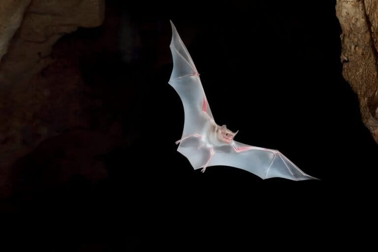
Kenyan scientists are studying bats emerging from coastal caves to learn more about these little-known creatures and how they interact with their environment, which could have implications for conservation.

Researchers developed a new model called AlphaEarth that can map global land cover with high accuracy, providing insights into the state of the planet that could inform environmental policies and decision-making.
Heavy rainfall in Hawaii caused severe flooding, threatening a nearby dam and forcing evacuations. This extreme weather event underscores the growing threat of climate change-driven natural disasters that can put communities at risk.
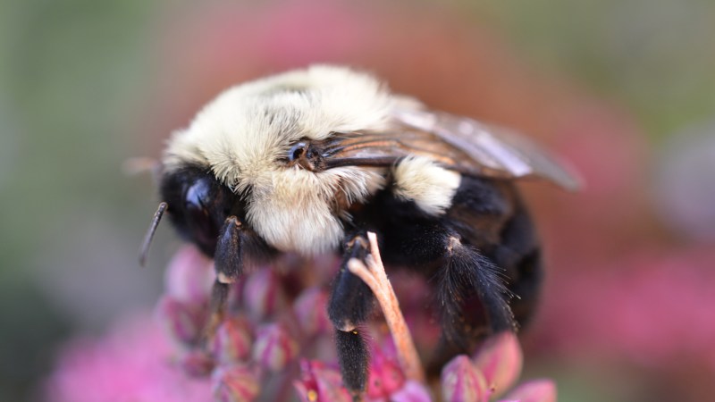
Bumblebee queens can breathe underwater, which may help them survive floods and natural disasters that threaten their hives and colonies.

Scientists are using new camera and AI technology to better track progress in global efforts to protect endangered insects, which are crucial for healthy ecosystems.

Influential ecologist Paul Ehrlich, known for warning about overpopulation, has died at age 93. His controversial predictions about population growth and resource scarcity sparked important debates about sustainability and public policy.
Abundant rain turned Australia's arid "Red Centre" into a lush green landscape. This rare event highlights how climate change can rapidly transform ecosystems, with potential impacts on local wildlife and communities.
Farmers in the Andes had to adapt or migrate when their maize-based agriculture faced crisis, revealing the vulnerability of local food systems to environmental changes.

Kitchen sponges release microplastics during use, which can contribute to household pollution and end up in the environment, raising concerns about potential health and environmental impacts.

Scientists discovered two mammal species in Indonesia that were thought extinct for 6,000 years, giving hope for uncovering more hidden biodiversity.

Measurements of certain elements in meteorites reveal new insights into how heavy elements are formed in dying stars. This information helps us better understand the chemical origins of the solar system.

Bangladeshi housing models designed to withstand climate disasters are not being widely adopted, leaving many vulnerable to recurring floods, storms, and erosion.
The mayor of Paris removed many parking spaces to drastically reduce the number of cars, which aims to lower pollution and make the city more livable for residents.

A volunteer in a mesh suit helped researchers observe how mosquitoes target and reach their hosts, providing insights into mosquito sensory and feeding behavior that could inform better mosquito control methods.

A critically endangered monkey gave birth after surgery saved its foot, offering hope for the species' recovery and demonstrating the power of veterinary care to protect vulnerable wildlife.
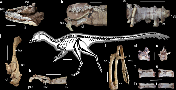
Paleontologists discovered a well-preserved dinosaur skeleton in Argentina that sheds new light on the evolution of a puzzling group of small, specialized dinosaurs known as alvarezsauroids.

Record-breaking March heat waves scorch the American Southwest, posing dangerous health risks and highlighting the intensifying impacts of climate change.
Astronomers found that globular star clusters floating freely between galaxies in galaxy clusters can reveal how those galaxy clusters formed over time. This helps scientists better understand the overall structure and evolution of galaxy clusters.

Generative AI systems like ChatGPT can now represent and reason about geography, which could impact how people understand and interact with physical spaces through these AI tools.
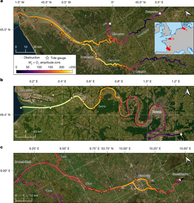
New satellite data maps tidal pulses in rivers, revealing how far inland ocean tides reach - key for coastal communities' flood planning.
Paleontologists discovered a well-preserved dinosaur skeleton in Argentina that sheds new light on the evolution of a puzzling group of small, specialized dinosaurs known as alvarezsauroids.
Researchers developed a new model called AlphaEarth that can map global land cover with high accuracy, providing insights into the state of the planet that could inform environmental policies and decision-making.
Measurements of certain elements in meteorites reveal new insights into how heavy elements are formed in dying stars. This information helps us better understand the chemical origins of the solar system.

New AI system helps analyze satellite images to track forest changes, improving monitoring of deforestation and environmental conservation efforts.

A new model simulates how Venus' internal heat, crust, and atmosphere evolved over time, providing insights into the planet's mysterious history and potential for volcanic activity.
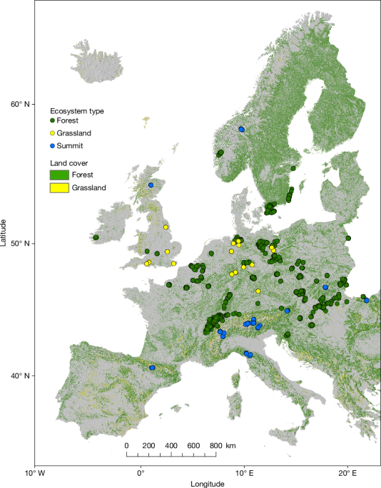
Forests, grasslands, and alpine areas are seeing changes in their plant and animal communities as the climate warms, with potential impacts on ecosystem services like food production and tourism.

Researchers developed AI-powered devices that can plant coral reefs on a large scale, which could help restore the dying Great Barrier Reef and protect vulnerable marine ecosystems.

Scientists created a new algorithm to better simulate complex geological data, which could help with tasks like mining and energy exploration.
Researchers developed a new algorithm to improve how computers model underground oil and gas reservoirs, which could lead to more accurate predictions about how much fuel is available and where it's located.

Researchers found that the heat flow in a promising semiconductor material called rutile GeO2 varies with temperature, which is important for designing efficient power electronics that can dissipate heat well.
Researchers studied a rare meteorite fragment, finding that its mineral composition provides a precise timeline of its formation and evolution billions of years ago. This gives new insights into the early history of our solar system.

Researchers developed a new system that can accurately predict airflow and pollution levels in cities, helping urban planners improve air quality and reduce public health risks.
Astronomers found that globular star clusters floating freely between galaxies in galaxy clusters can reveal how those galaxy clusters formed over time. This helps scientists better understand the overall structure and evolution of galaxy clusters.

Astronomers find evidence that a star similar to our Sun experienced a long period of unusually low magnetic activity, which could provide insights into past changes in the Earth's climate.
Scientists have used satellite data to map tidal patterns in rivers, which can help understand how climate impacts coastal regions.

New analysis of Milky Way stars reveals the edge of our galaxy's star-forming region, providing insights into how galaxy discs form and evolve over time.
Researchers developed a new computer model to predict urban air flow and pollution levels, which could help cities improve air quality and protect public health.

Large Mars-sized objects in forming planetary systems can disrupt their own local environment through turbulence, limiting the effectiveness of the thermal forces that shape their orbits.