Story
Observing the tidal pulse of rivers from wide-swath satellite altimetry
Key takeaway
New satellite data maps tidal pulses in rivers, revealing how far inland ocean tides reach - key for coastal communities' flood planning.
Quick Explainer
The study used data from the new SWOT satellite to comprehensively map tidal influences across over 165,000 km of coastal rivers worldwide. By analyzing the satellite's wide-swath measurements, the researchers were able to quantify the diurnal and semi-diurnal tidal patterns that profoundly impact these land-ocean transition zones. This pioneering effort provides the first global atlas of tidal rivers, enabling new scientific understanding of estuarine dynamics, freshwater resources, and carbon budgets. The SWOT dataset's high resolution overcame limitations of previous altimetry methods, revealing tidal extents that affect an estimated 715 million people living nearby.
Deep Dive
Technical Deep Dive: Observing the Tidal Pulse of Rivers from Wide-Swath Satellite Altimetry
Overview
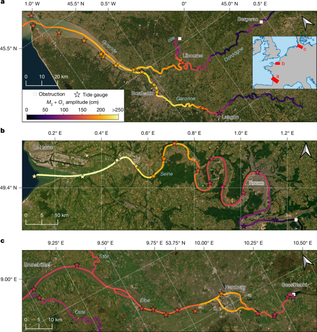
This study used data from the recently launched Surface Water and Ocean Topography (SWOT) satellite to characterize the tidal dynamics across 3,172 coastal rivers worldwide. The high-resolution wide-swath coverage of SWOT enabled the researchers to quantify tidal influences over more than 165,000 km of river extent, impacting over 700 million people living near these coastal transition zones.
Problem & Context
- Tides profoundly influence coastal environments, affecting navigation, water properties, sediment transport, and more.
- However, the extent of tides in most of the world's coastal rivers was previously unknown due to limitations of traditional altimetry and a lack of gauging stations.
- This study aimed to pioneer a global understanding of tidal dynamics within rivers using the new capabilities of the SWOT satellite.
Methodology
- The researchers conducted harmonic analysis on SWOT's River Single-Pass Vector Data Product (RiverSP) from March 2023 to May 2025 to estimate the diurnal (O1) and semi-diurnal (M2) tidal constituents.
- They validated the SWOT tidal amplitude estimates against 622 in-situ tide and river gauge stations globally.
- Tidal amplitudes were classified into four categories (tidal, likely tidal, likely not tidal, not tidal) based on thresholds for confidence interval, signal-to-noise ratio, river topography, and minimum amplitude.
- The classified tidal extents were analyzed in relation to river characteristics like Strahler order, slope, and mouth width.
Results
- Over 165,000 km of the world's coastal rivers were found to be influenced by tides.
- Tidal extent scales roughly with Strahler order, slope, and mouth amplitude, but significant local complexities also exist.
- 16% of the observed tidal rivers have artificial or natural obstructions that limit tidal propagation.
- An estimated 715 million people live within 10 km of a tidal-influenced river.
Interpretation
- The SWOT dataset enables the first comprehensive global atlas of tidal rivers, opening new possibilities for monitoring and modeling changes in estuarine habitats, freshwater resources, and carbon budgets.
- Tidal data from SWOT can improve the analysis of historical floods and droughts on tidal rivers, as well as support the development of predictive models for saltwater intrusion.
- This study demonstrates the power of wide-swath satellite altimetry to advance scientific understanding of land-ocean interactions.
Limitations & Uncertainties
- The current SWOT time series is too short to resolve complex tide-river interactions dependent on river discharge.
- Small streams under 30-90 m width are undersampled, potentially leading to conservative estimates of total tidal river extent.
- Tidal amplitude estimates have increasing uncertainty further upstream due to decreasing signal-to-noise ratio.
What Comes Next
- As the SWOT mission continues, an extended time series will enable resolving more tidal constituents and better characterizing non-stationary tidal processes.
- Integrating SWOT tidal data into hydrodynamic and AI models could significantly improve monitoring and prediction of coastal flooding, saltwater intrusion, and other land-ocean interactions.
- Future satellite missions building on SWOT's capabilities could further refine the global atlas of tidal rivers.