Story
Observing the tidal pulse of rivers from wide-swath satellite altimetry
Key takeaway
Scientists have used satellite data to map tidal patterns in rivers, which can help understand how climate impacts coastal regions.
Quick Explainer
The SWOT satellite provides the first comprehensive global view of tidal dynamics within rivers. By using wide-swath altimetry data, SWOT can quantify the extent to which tides propagate inland, their dissipation by natural and artificial obstacles, and their influence on processes like flooding and saltwater intrusion. This dataset reveals how tidal amplitudes scale with river size and other characteristics, enabling new interdisciplinary research at the land-ocean interface. The SWOT tidal data can be integrated into models to identify at-risk coastal communities and support climate adaptation efforts, addressing a longstanding gap in our understanding of tidal river systems.
Deep Dive
Observing the Tidal Pulse of Rivers from Wide-Swath Satellite Altimetry
Overview
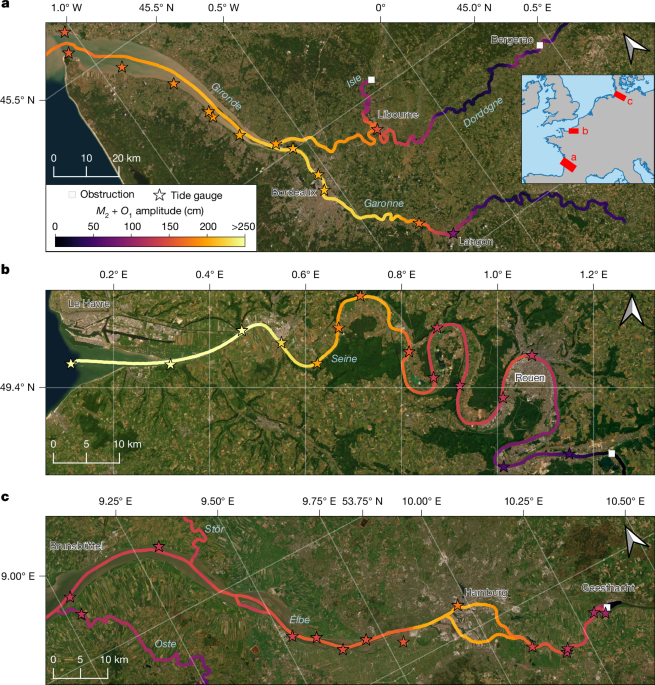
- The Surface Water and Ocean Topography (SWOT) satellite enables the first comprehensive global observations of tidal dynamics in coastal rivers.
- SWOT's wide-swath coverage allows quantifying tidal influence across 165,000 km of the world's coastal rivers, where over 700 million people live.
- The dataset reveals the extent to which tides propagate inland, their dissipation by natural and artificial obstacles, and their influence on processes like flooding, saltwater intrusion, and carbon budgets.
Problem & Context
- Tides profoundly affect estuarine and wetland habitats, freshwater supply, biogeochemical cycles, and sediment transport in coastal rivers.
- However, the extent of tidal influence has been poorly known globally due to the complexity of tidal propagation and the sparsity of in-situ observations.
- Conventional satellite altimetry has been too sparse to capture the spatial variability of tides in rivers.
Methodology
- Analyzed SWOT River Single-Pass Vector Data from March 2023 to May 2025 to estimate the amplitudes of the dominant M2 and O1 tidal constituents at each observed river node.
- Validated SWOT tidal estimates against 622 in-situ tide and river gauge stations globally.
- Classified river nodes as tidal, likely tidal, likely not tidal, or not tidal based on a set of criteria including tidal amplitude, signal-to-noise ratio, and river topography.
- Analyzed relationships between tidal extent and river characteristics like Strahler order, slope, and mouth width.
- Identified river obstructions (dams, waterfalls) that limit tidal propagation.
Results
- Over 165,000 km of the world's coastal rivers are influenced by tides, affecting 715 million people living nearby.
- Tidal extent scales with river size (Strahler order) and is also influenced by slope and mouth width.
- 16% of observed tidal rivers have artificial or natural obstructions that limit the tidal extent.
- SWOT tidal data can improve the analysis of historical floods and droughts on tidal rivers, and support modeling of saltwater intrusion and coastal carbon budgets.
Interpretation
- The SWOT dataset provides the first global view of tidal dynamics within rivers, enabling new interdisciplinary research at the land-ocean interface.
- Tidal amplitudes from SWOT can be used to refine analyses of extreme flows, saltwater intrusion, and coastal carbon budgets in tidal rivers.
- The data can be integrated into models to identify at-risk coastal communities and support climate adaptation efforts.
Limitations & Uncertainties
- The current SWOT time series is too short to fully resolve complex tide-river interactions and the dependence of tides on river discharge.
- Smaller first- and second-order streams are undersampled due to SWOT's resolution limits.
- Errors increase with distance upstream from the river mouth, and can be influenced by factors like sea ice at high latitudes.
What Comes Next
- Extending the SWOT time series will enable the derivation of more tidal constituents and the study of non-stationary tidal processes.
- Integrating SWOT tidal data with river discharge, water quality, and other observations will advance understanding of coupled hydrological-oceanographic processes.
- Future satellite missions building on SWOT's capabilities can further refine global tidal estimates in rivers.